Argyle Forest
The small remnant Jarrah forest known as Argyle forest, lies to the west of Donnybrook, sandwiched between the Capel and Preston Rivers. It stretches roughly 12 kilometres east-west and 10 kilometres north-south. The map of the forests of the south west shows the location of the forest.
Small scale logging occurred in the forest, way back in the 19th Century. However, when the Government Railway between Bunbury and Donnybrook was completed in 1893, several timber operations set up mills in the area and extensive logging of the surrounding jarrah forest began. In 1905 Bunnings bought a mill at Argyle and in 1907 they acquired the timber concession to the forest south of Argyle, down as far as the Capel River.
Over the next thirty years they built a network of bush railways, following the valleys up into the forest. Horse drawn whims hauled the logs down from the surrounding hillsides to the nearest bush landing, for loading on to the trains. Much of the track was temporary; sleepers were laid directly on to the forest floor with only every third one dog spiked. Simple log bridges carried the track over the many creeks. Once an area had been logged, the track was taken up and laid somewhere else.
The operation ceased in 1940 and the track and machinery removed to other operations; however, traces of the bush railways remain today. Many of the old railway formations have become four wheel drive tracks, while others lie hidden and forgotten in the deep forest. This walk rediscovers some of these formations and bush landings.
The 15 kilometre long walk starts and finishes at a small gravel pit on the edge of the forest and follows easily distinguishable tracks for most of the way. It takes around 5 hours to complete. A short diversion follows old railway sleepers laid directly on to the forest floor. They lead to an old bush landing where the track terminates. This part of the forest is well worth a visit, though it requires good navigational skills. |
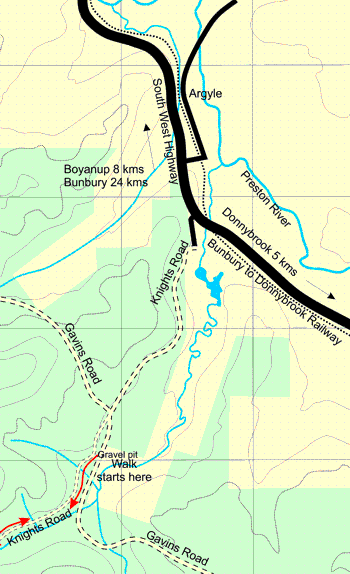 |
| The start of the walk at Knights Road | How to get here
From Bunbury, follow the South West highway through Boyanup, and continue a further 8 kilometres to the Knights Road turn off; it’s just before the road crosses the railway line. Turn right on to Knights Road.
From Donnybrook, follow the South West Highway for five kilometres and turn left on to Knights Road; it’s just after the railway crossing.
Follow Knights Road for 2 kilometres until it joins up with Gavins Road. Knights Road then becomes the narrow forest track leading into the forest. Drive along this track for about 200 metres, to the gravel pit on the left, and park.
Forest disease regulations prevent motor vehicles from proceeding any further down Knights Road. However as you’ll see, these regulations are routinely flouted by four wheel drive vehicles. |
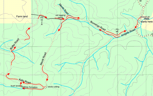
Start of the walk – the gravel pit to the old logging camp at Meotti Road 3.25 kms.
Walk south west along Knights Road, for a kilometre, to the junction marked by the reference tree FD 46 2. Take the track to the North West, Bunnings Road, and follow it up the valley for two kilometres to Meotti Road. All of these tracks follow old railway formations.
No sign post marks the junction with Meotti Road. One branch heads North West up a hill and the other follows the valley South West, take this track. After a hundred metres or so the creek bed will be on your left and you’ll see a series of overgrown terraces on your right, the remains of an old logging camp. The walk returns to these terraces later in the day.
|
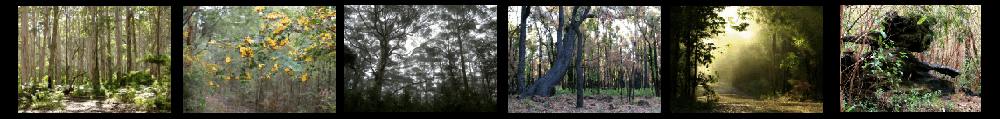
The walk mostly follows old railway formations through the remnant jarrah forest. |
|
|
The old logging camp to the stone cutting on Meotti Road 2.5 kms.
Continue South West along Meotti Road. The track turns south to cross the creek bed at an old stone bridge then continues south west to climb the hill side. This would have been a considerable gradient for the small steam locomotives hauling the sets of wagons up into the forest, and particularly hazardous on the descent when they were fully laden with logs.
At the top of the hill the walk bears south east and then south. To the east of the track you’ll see some piles of stones. Take a closer look and you’ll discover a stone cutting or bush landing, once used to haul the logs onto the wagons.
The stone cutting to Buffer Road, along Kelly Road 1.75 kms.
Continue along Meotti Road to the junction with Kelly Road, about 100 metres from the stone cutting. Meotti Road turns south here and Kelly Road heads North West.
To reach Buffer Road directly, follow Kelly Road for just under 1˝ Kilometres.
To follow the old railway, walk about 60 metres down Meotti Road and then walk North West into the bush for about 20 metres. Look around for the remains of old railway sleepers. If you find them, follow them west into the forest. The indistinct trail of sleepers continues for a kilometre and ends at a bush landing. Few people visit this part of the forest and it’s a good opportunity to see what the forest would be like if it weren’t continually hammered by four wheel drive vehicles. However, the trail is hard to follow so if you lose it, and become lost; head north to intersect Kelly Road.
From the bush landing simply walk north for about 200 metres to intersect Kelly Road. Then follow Kelly Road west to Buffer Road.
Buffer Road back to the old logging camp on Meotti Road 4.0 Kms.
Follow Buffer Road north west for about 3 kilometres. The track is clearly not a railway formation; it twists and turns, rising and falling, as it crosses the hills and valleys. After 1 kilometre it crosses a prominent creek, and a kilometre and a half beyond this a side track descends north west to the forest boundary and nearby farm land. The overgrown track back to the old logging camp is half a kilometre beyond this. It’s at a cross roads with a sign post (though the sign has fallen off). The forest reference tree (FD 44 2 R) is about 20 metres up the track and not visible from buffer Road.
Follow the trail over the ridge and back to the old logging camp. As you approach the logging camp, the terraces become apparent and you will see Meotti Road to the south east. It's just beyond the two trees that have fallen across the trail. Descend the terraces to return to Meotti Road.
Return via Bunnings and Knights Roads 3.25kms.
From the logging camp, follow Meotti Road north east to the junction with Bunnings Road. Follow Bunnings Road south east to knights Road and then Knights Road north east to the gravel pit and the start of the walk.
Back to Top
|
|
When to visit
The walk can be made at any time of the year, but August, September and October are the best months for wildflowers.
The forest is regularly burnt as part of a fuel reduction regime; so much of its biodiversity is lost. The plants that survive this regime best are those that grow from a lignotuber, and of course orchids.
Take note of any signs indicating that a fuel reduction burn is about to take place. Control burns sometimes get out of control.
What to take
A map and compass is essential and a GPS would be very useful.
Download a printer friendly and GPS compatible version of the walk.
Argyle forest walk pdf file, 782kB

The forest reference tree (FD 46 2) at the junction of Knights Road and Buffer Road
|